
Road Trip 2025: Day 3
- Elizabeth Jaeger

- Jul 14, 2025
- 5 min read
We survived the night in the deserted campground. When we woke up the grass and our tents were saturated with dew and the air was a chilly fifty-five degrees. I slept decently, about as well as I ever sleep. We broke camp quickly and were on the road by seven. Our goal for the day was to drive through Nebraska. It feels huge and empty. Like Iowa, we are surrounded by big open fields and farms. So many farms. And so many cattle crammed into small spaces. It’s actually really depressing to see all those animals sitting in the hot sun waiting to be slaughtered.
The three of us are all famished. Sunday morning in Nebraska means all restaurants are apparently closed. Where is everyone? We aren’t even in the Bible belt, but I suppose we are in rural red America which means it’s entirely possible that while we are making our way west, the locals are sitting in church. We are no longer on the interstate. Kati wants to visit Carhenge, a brief detour away from the more direct route. Therefore, we are traversing county roads instead. It actually makes for a more peaceful relaxing drive. There are few cars on the roads so we can drive as fast, and the scenery, while redundant, is pretty.
Driving through the Great Plains of western Nebraska, we rolled down the windows allowing the fresh air to assault us. With hair whipping around, we raised the volume on our playlist to enjoy the music along with the freedom of the road. For miles, all we saw were gentle rolling hills as far as our eyes could see. The only signs of civilization in sight were fences—obviously a series of cattle ranches—the occasional clump of grazing cattle, and the railroad.
Carhenge was interesting. It is located just north of Alliance, Nebraska and it was built and designed by Jim Reinders. While living and working in England, Reinders became fascinated by Stonehenge, so he took the time to study it, specifically its history and layout. When he returned to the United States, he felt compelled to build a replica, not with stones but with cars. In 1987, he erected Carhenge—cars mimicking the placement of stones—with the help of his family. It is a memorial to his Dad and it sits on land that was once a farm where his dad lived. When Kati first read about it, while doing research for this trip, she insisted we add it to our itinerary. I figured I’ve dragged her all over the country to see historic sites, if this made her happy—especially since she does most of the driving—why not make the detour.

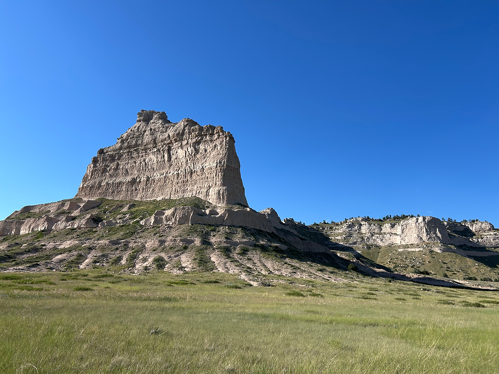
Our next stop was Scotts Bluff National Monument, tall land formations that call to mind the Badlands in South Dakota. The formations are also reminiscent of drip sandcastles at the beach, those pretty castles you get when you let the wet sand fall through your fingers. Only Scotts Bluff looks like it’s been baking in the sun for centuries, which it has. The Bluff is along what once was the Oregon Trail. Thousands of pioneers pushing west—on the Mormon Trail, the Oregon Trail, or in search of gold in California—traveled through the shadow of Scott’s Bluff.
But way before people of European decent ever set eyes on the bluffs, numerous Native American tribes lived on the land and hunted buffalo for sustenance. The first white people to record seeing the bluffs were fur traders from John Jacob Astor’s Pacific Fur Company in 1812. Fur trappers often utilized the Platte River Valley. Hiram Scott was one of those trappers and the legend regarding him has several variations. He was heading back east when he either fell sick from one of many diseases that killed people back in those days, or he was injured in a skirmish with the Blackfeet. Either way, he was unable to continue on and so his trapping buddies left him behind not far from the bluffs. The following year, his bones were allegedly discovered, evidence that he did not survive, and so the bluffs were named after him.
Hiram Scott was not the only person to die on what would become the Oregon Trail. Medical science was practically nonexistent and disease plagued the pioneers, as did attacks by Native Americans who were bitter and angry that the whites were invading, stealing, and settling on their land. The dead were often buried on the trail. The constant traffic, oxen walking over the earth and beating it down, ensured the dead would remain buried. Scotts Bluff is the second most common landmark referenced in pioneer diaries. Only Chimney Rock is mentioned more.
When we arrived at Scotts Bluff we drove up to the observation point which gave us some gorgeous views of the Bluff and the valley. However, pulling into a parking spot, we saw a park ranger walk over to an older slightly overweight man sitting in a blue Volkswagen Bug. The man was blasting music, but we still heard the ranger say, “I know you were smoking marijuana. I can smell it…please lower your music.” Since we were short on time—the park was closing in just over an hour—we didn’t have time to linger for the drama, so we unfortunately had to walk away if we were going to reach the first observation point. It was a short walk, only two tenths of a mile, but the view was amazing.
When we returned to the car, police had shown up—two cops, each in their own car—and they were searching the Bug. G3 and Kati opted not to accompany me to the second point. It was slightly further, but not more beautiful. By the time we left, the cops had collected two joints for their evidence bag. Marijuana is not legal in Nebraska, but more importantly, the guy was on Federal grounds so state laws don’t matter.
Down at the visitor center, we watched a video about the bluffs and the Oregon Trail, and then I, of course, had to walk around to take more pictures. By the time we got back into the car we noticed the Bug was making its way down from the observation point and the stoned man was driving. As we left the lot, we pulled behind the Bug and I was absolutely appalled that the cops allowed him to get behind the wheel. He was so high he was incapable of driving in a straight line. He kept veering into the lane of oncoming traffic.
Anyway, we turned off that road in search of a campground. Luckily, we found one close by at Riverside Park. It’s by no means a great place to camp, but it is convenient and they had lots of available sites to choose from. We are so close to the main road we can hear the constant sound of cars zooming by. There are also train tracks and the noise from the train nearby. But, mixed in with all those lovely sounds of civilization are the cicadas, chirping away like a familiar lullaby.
Oh, and yes we did find food. We had to wait until we reached Alliance, but there we had several options to choose from and G3 settled on Subway.


Comments